

Have you ever stood on a bridge and watched the water rushing aggressively away beneath your feet? Where exactly is it going in such a massive hurry? Water never just sits completely still unless it is trapped in a tiny garden puddle. It is always on a grand, messy adventure, travelling all the way from the high, snowy mountain peaks down to the salty ocean. Today, we are taking a deep dive into these giant, flowing ribbons of water. We will uncover exactly how they carve through heavy rock, why animals absolutely rely on them, and the hidden geographical vocabulary used to describe their journey.
Understanding the Basics: Everything about river Systems
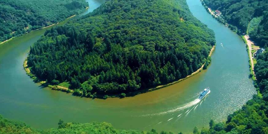
Let us start right at the very beginning. If you are learning about river paths with your child, you have to picture them exactly like giant, natural water slides. A river is simply a large, natural stream of flowing water moving across the land. It usually starts incredibly high up in the freezing hills or rocky mountains, often from a slowly melting glacier or a tiny, bubbling underground spring.
Because gravity is constantly pulling absolutely everything downwards, this tiny, fragile stream trickles down the hillside. Along the way, it joins up with other tiny streams, getting significantly wider, deeper, and much faster as it travels. It acts like a massive conveyor belt, dragging heavy mud, tiny pebbles, and broken branches all the way across the country until it eventually crashes directly into the sea.
Read More – Interesting Facts about the Amazon River For Students
Learning about river in English: Key Geography Terms
When young kids first start learning physical geography, the heavy textbook vocabulary can sometimes feel a bit overwhelming. Breaking down facts about river in English helps young, curious minds grasp the actual science behind the pretty scenery.
Here are the most vital words your child needs to know to decode the map:
- Source: This is the absolute starting point of the journey. It is where the water first pops out of the rocky ground or where the mountain snow officially melts.
- Tributary: Think of this as a smaller side-street of water that eventually crashes into the main, bigger channel.
- Mouth: This is the grand, final finish line. It is the exact spot where the fresh, flowing water finally dumps into the massive, salty sea or a giant lake.
- Delta: Sometimes, right before the finish line, the water slows down drastically and spreads out into a massive, muddy, fan-like shape, dropping all the heavy dirt it carried along the way.
Detailed river information in English: Why Are They Important?
Providing solid river information in English goes way beyond just naming the different wet parts of a map. We have to properly explain why these flowing paths actually matter to our daily survival. They are the absolute, undeniable lifelines of our planet. Without them, our towns would have absolutely no clean drinking water, and our local farmers would be entirely unable to grow the massive fields of wheat and crunchy vegetables we eat for dinner.
They also act as brilliant, bustling highways and safe homes for millions of fish, frogs, and hunting birds. In our Heureka Curriculum, we strongly encourage children to explore these wild, natural connections. By playing and investigating, they quickly understand that pulling one tiny string in nature always affects something else entirely, building a deep, lasting empathy for the environment.
Fascinating facts about rivers Around the World
Kids absolutely love wild, record-breaking trivia. Sharing incredible facts about rivers easily turns a boring afternoon geography lesson into a thrilling story of survival and scale.
For example, did you know that the famous Nile in Africa is widely considered the longest in the entire world? It stretches for over four thousand miles through scorching deserts! Or how about the mighty Amazon over in South America? It is so incredibly wide in some specific places during the wet season that you cannot even see the opposite bank with a telescope. It pushes out more fresh water into the ocean than the next seven biggest rivers combined. Sharing these massive, mind-boggling numbers helps children realise just how giant and powerful the natural world truly is.
Read More – Science Quiz Questions and Answers for Kids
Amazing facts about rivers of India: Our Flowing Lifelines
We definitely do not have to look all the way to the South American rainforest to find incredible water systems. There are absolutely breathtaking facts about rivers of India that every child should proudly learn.
The Ganga is not just a massive body of water; it is a deeply revered, sacred lifeline for millions of families, providing essential hydration for massive farming lands all across the northern plains. Then there is the fierce Brahmaputra, which is so unbelievably powerful and wide that it completely transforms the physical landscape of the northeast every single year during the heavy monsoon season. Further south, the Godavari winds its way across the peninsula, sustaining entire ecosystems. Teaching kids about their local, regional geography builds a massive sense of cultural pride and urgent environmental responsibility.
A few lines about rivers for Kids to Remember
If your child needs to quickly memorise a few lines about rivers for a school project, or if you just want to give them a simple, snappy summary before bedtime, here is a highly effective list of takeaways:
- They always, without fail, flow downhill because gravity violently pulls the heavy water towards the sea.
- Clean freshwater is incredibly rare on Earth, and these flowing streams hold a massive chunk of our accessible drinking supply.
- They physically carve out giant valleys and deep, rocky canyons over millions of years just by rubbing violently against the stone.
- Early humans always built their biggest, most famous historical cities right next to the muddy banks for easy boat travel and reliable farming.
Read More – Real Difference Between Oceans & Rivers and Lakes
Conclusion
It is genuinely thought-provoking to look closely at a colourful world map and realise that these twisting, blue lines are essentially the beating veins of our planet. They constantly pump life, raw energy, and vital nourishment into every single dusty corner of the globe. If they dry up due to extreme heat or become heavily choked with our plastic pollution, the entire natural system completely collapses. Teaching our children to fiercely respect and protect these massive waterways is not just a standard school lesson; it is a crucial, non-negotiable survival skill for their future. When we teach kids how the wild world actually works, we hand them the heavy tools needed to eventually fix it. Discover more brilliant ways to satisfy your child’s endless curiosity by visiting the EuroKids Blog and take the first confident step towards a vibrant educational journey today via EuroKids Preschool Admission.
FAQs
Why is river water completely fresh while the massive ocean is salty?
As rain falls, it creates freshwater streams. While these streams do carry tiny, invisible amounts of salt washed from the rocks into the sea, the ocean acts as a giant bucket collecting that salt for millions of years, making the sea incredibly salty while the flowing streams remain fresh.
Do all of these waterways eventually reach the ocean?
Most of them do, but not absolutely all of them! Some dry up completely in the baking desert heat before they reach the coast, while others flow directly into totally landlocked, inland lakes.
What is the absolute fastest way for a child to learn local geography?
Get them outside! Taking a slow weekend walk along a local riverbank, spotting the wild ducks, and throwing tiny twigs into the moving current is always far more effective than staring at a dry, boring textbook.